Growing Plants On The Ranch

Growing Plants On The Ranch
Growing Plants On The Ranch
Santa Fe Trail Ranch has a legacy of aggressively controlling noxious weeds that can invade ranch property and rob the land of precious moisture. The POA provides herbicide that effectively controls various types of thistle, Mexican locust, Houndstongue, and Mullen when properly applied. The herbicide is provided to property owners in early spring and it can be applied throughout the growing season.
SFTR resident Carol Rawle just published a very informative article "A Thistle Wildfire" in Articles->Plants & Gardening.
Many property owners graciously volunteer to patrol assigned ranch road segments and apply herbicide as needed to control noxious weeks along roads/ditches and in the conservancy. As with all chemicals, personal protective equipment such as gloves and masks are recommended when applying this material.
The following map divides the ranch roads into numbered segments, and the volunteers who are currently signed up for the segments are shown in the table below the map.
Contact Bill Latham at 619-884-7682 or orangelatham@gmail.com for info on the POA-provided herbicide.
Contact Bill Nielsen at 360-977-8766 or wpnielsen@msn.com to sign up for road segments.
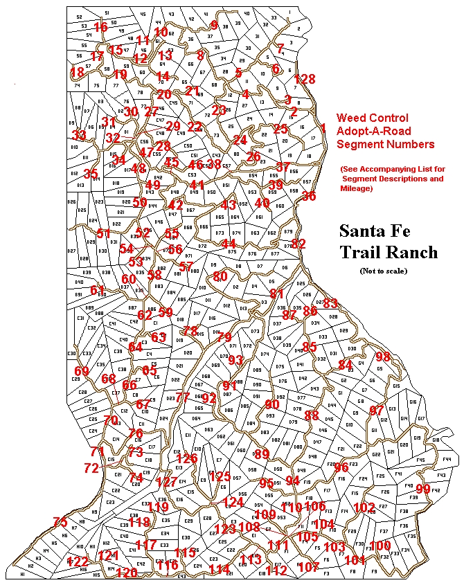
Noxious Weed Control Adopt-A-Road Map.pdf
The following list was updated per Bill Nielsen on April 23rd, 2023.
| Segment | Roadway | From | To | Miles | Adopted By |
| 28 | Westwood Drive | 0.75 | AVAILABLE | ||
| 34 | Deer Trail Lane | 0.25 | AVAILABLE | ||
| 59 | Porcupine Circle | 0.35 | AVAILABLE | ||
| 67 | Wild Plum Lane | 0.36 | AVAILABLE | ||
| 72 | Bobcat Court | 0.35 | AVAILABLE | ||
| 73 | Wild Wood Lane | 0.34 | AVAILABLE | ||
| 74 | Meadow Court | 0.27 | AVAILABLE | ||
| 77 | Gallinas Parkway | Tall Oaks Drive | Engleman Court | 1.28 | AVAILABLE |
| 78 | Engleman Court | 0.78 | AVAILABLE | ||
| 80 | Mountain Meadow OL | 2.08 | AVAILABLE | ||
| 81 | Gallinas Parkway | Mountain Meadow OL | Fisher Peak Parkway | 1.01 | AVAILABLE |
| 85 | Old Mission Ridge | Timber Park Drive | Timber Wolf Run | 0.69 | AVAILABLE |
| 86 | Old Mission Ridge | Timber Wolf Run | End | 0.27 | AVAILABLE |
| 87 | Timber Wolf Run | Old Mission Ridge | End | 0.34 | AVAILABLE |
| 99 | Alpine Meadows Drive | Fisher Peak Parkway | Yucca Court | 3.86 | AVAILABLE |
| 100 | Yucca Court | 0.2 | AVAILABLE | ||
| 101 | Alpine Meadows Drive | Yucca Court | Lodgepole Trace | 0.53 | AVAILABLE |
| 103 | Alpine Meadows Drive | Lodgepole Trace | Juniper Overlook | 0.34 | AVAILABLE |
| 104 | Juniper Overlook | 0.18 | AVAILABLE | ||
| 105 | Alpine Meadows Drive | Juniper Overlook | Aspen Trail | 0.39 | AVAILABLE |
| 106 | Alpine Meadows Drive | Aspen Trail | Timber Park Drive | 0.07 | AVAILABLE |
| 110 | Timber Park Drive | Locust Court | Alpine Meadows Drive | 0.63 | AVAILABLE |
| 111 | Timber Park Drive | Alpine Meadows Dr. | Gallinas Parkway | 0.39 | AVAILABLE |
| 123 | Gallinas Parkway | Squirrel Lane | Trail Ridge | 0.89 | AVAILABLE |
| 124 | Trail Ridge | Gallinas Parkway | Fawn Court | 0.08 | AVAILABLE |
| 125 | Fawn Court | 0.3 | AVAILABLE | ||
| 126 | Trail Ridge | Fawn Court | End | 0.78 | AVAILABLE |
| 127 | Gallinas Parkway | Trail Ridge | Tall Oaks Drive | 1.4 | AVAILABLE |
| 1 | Fisher Peak Parkway | Cottonwood Canyon | Little Bear Drive | 0.79 | Kinder, R |
| 2 | Little Bear Drive | Fisher Peak Parkway | Raton Overlook | 0.62 | Kinder |
| 3 | Raton Overlook | 0.34 | Kinder | ||
| 4 | Little Bear Drive | Raton Overlook | Oak Park Drive | 0.85 | Kinder |
| 5 | Oak Park Drive | Little Bear Drive | North End | 1.29 | Latham, B |
| 6 | Pinon Court | 0.47 | Klebba | ||
| 7 | Pass Creek Court | 0.08 | Scott, R. L. | ||
| 8 | Little Bear Drive | Oak Park Dr | Vista West Drive | 1.39 | Latham, B |
| 9 | Vista West Drive | Little Bear Drive | North End | 0.94 | Wichterman |
| 10 | Vista West Drive | Little Bear Drive | Vista West Court | 0.56 | J&C Smith |
| 11 | Vista West Court | 0.06 | J&C Smith | ||
| 12 | Vista West Drive | Vista West Court | Wildlife Run | 0.53 | Tollefson |
| 13 | Wildlife Run | Vista West Dr | End | 0.72 | Tollefson |
| 14 | Pine Nut Dr | 0.37 | Scott, R. L. | ||
| 15 | Vista West Drive | Spruce Lane | Cedar Way | 0.44 | Parker, John |
| 16 | Cedar Way | 0.3 | Scott, R. L. | ||
| 17 | Vista West Drive | Cedar Way | Elk Park Road | 0.48 | Parker, John |
| 18 | Vista West Drive | Elk Park Road | End | 0.51 | Parker, John |
| 19 | Elk Park Road | Vista West Dr | Mountain View | 0.96 | Latham |
| 20 | Elk Park Road | Mountain View | Oak Way | 0.26 | Dixon, Ken |
| 21 | Oak Way | 0.34 | Dixon, Ken | ||
| 22 | Elk Park Road | Oak Way | Oak Park Drive | 1.26 | Klebba |
| 23 | Oak Park Drive | Elk Park Road | Little Bear Drive | 0.96 | Clarke |
| 24 | Elk Park Road | Oak Park Dr | Ponderosa Ridge Dr | 0.53 | Klebba |
| 25 | Ponderosa Ridge Dr | 0.99 | Klebba | ||
| 26 | Elk Park Road | Ponderosa Ridge Dr | Cottonwood Canyon | 0.98 | Klebba |
| 27 | Mountain View | Elk Park Road | Westwood Drive | 0.49 | Wichterman |
| 29 | Mountain View | Westwood Drive | Cottonwood Canyon | 0.13 | Wichterman |
| 30 | Mora Lane | 0.33 | Henning / Peters | ||
| 31 | Cottonwood Canyon | Mountain View | W End | 0.27 | Beaver |
| 32 | Mountain View | Cottonwood Canyon | Meadow Ridge Lane | 0.03 | Wichterman |
| 33 | Meadow Ridge Lane | 1.1 | Beaver | ||
| 35 | Squaw Creek Lane | 0.33 | Oetter | ||
| 36 | Fisher Peak Parkway | Turkey Creek Lane | Cottonwood Canyon | 0.95 | McBride |
| 37 | Cottonwood Canyon | Fisher Peak Parkway | Elk Park Road | 1.01 | Bob Dye |
| 38 | Cottonwood Canyon | Elk Park Road | Elk Ridge Trail | 0.22 | Bob Dye |
| 39 | Elk Ridge Trail | 1.16 | Bob Dye | ||
| 40 | Eagle's Nest Overlook | 0.38 | Dye | ||
| 41 | Cottonwood Canyon | Elk Ridge Trail | Turkey Creek Lane | 0.7 | Beaver |
| 42 | Turkey Creek Lane | Cottonwood Canyon | Antelope Run | 1.45 | Beaver |
| 43 | Antelope Run | 0.4 | Beaver | ||
| 44 | Turkey Creek Lane | Antelope Run | Fisher Peak Parkway | 2.45 | Beaver |
| 45 | Cottonwood Canyon | Turkey Creek Lane | Hiddenwood Lane | 0.18 | Beaver |
| 46 | Hiddenwood Lane | 0.44 | Beaver | ||
| 47 | Cottonwood Canyon | Hiddenwood Lane | Mountain View | 0.63 | Beaver |
| 48 | Mountain View | Cottonwood Canyon | Bear Paw Lane | 0.71 | Wichterman |
| 49 | Bear Paw Lane | 0.18 | Edholm | ||
| 50 | Mountain View | Bear Paw Lane | Timber Ridge Lane | 0.54 | Forch |
| 51 | Timber Ridge Lane | 1.04 | Eisley | ||
| 52 | Mountain View | Timber Ridge Lane | Cedar Ridge Lane | 0.29 | Forch |
| 53 | Cedar Ridge Lane | 0.25 | Kirkwood | ||
| 54 | Mountain View | Cedar Ridge Lane | Chipmunk Drive | 0.15 | Forch |
| 55 | Chipmunk Drive | 0.5 | Edholm | ||
| 56 | Mountain View | Chipmunk Drive | Conifer Drive | 0.02 | Craig |
| 57 | Conifer Drive | 0.52 | Kirkwood | ||
| 58 | Mountain View | Conifer Drive | Porcupine Circle | 0.59 | Sharp |
| 60 | Mountain View | Porcupine Circle | Sunset Drive | 0.07 | Sharp |
| 61 | Sunset Drive | 0.72 | Forch | ||
| 62 | Mountain View | Sunset Drive | Currant Court | 0.49 | Tim Nash |
| 63 | Currant Court | 0.24 | Alexandrowicz | ||
| 64 | Mountain View | Currant Court | Ptarmigan Court | 0.52 | Tim Nash |
| 65 | Ptarmigan Court | 0.24 | Tim Nash | ||
| 66 | Mountain View | Ptarmigan Court | Wild Plum Lane | 0.45 | Tim Nash |
| 68 | Mountain View | Wild Plum Lane | Tall Timber Trace | 0.11 | Tim Nash |
| 69 | Tall Timber Trace | 0.98 | Russ Gorrell | ||
| 70 | Mountain View | Tall Timber Trace | Tall Oaks Drive | 0.49 | Kirkwood, J |
| 71 | Mountain View | Tall Oaks Drive | Bobcat Court | 0.38 | Chatelain/Kirkwood |
| 75 | Mountain View | Bobcat Court | Tank 2 | 1.75 | Kirkwood |
| 76 | Tall Oaks Drive | Mountain View | Gallinas Parkway | 1.21 | Kirkwood |
| 79 | Gallinas Parkway | Engleman Circle | Mountain Meadow OL | 0.85 | Cantin |
| 82 | Fisher Peak Parkway | Gallinas Parkway | Turkey Creek Lane | 0.59 | McBride |
| 83 | Fisher Peak Parkway | Gallinas Parkway | Old Mission Ridge | 1.62 | McBride |
| 84 | Old Mission Ridge | Fisher Peak Parkway | Timber Park Drive | 0.96 | Smith, Steve |
| 88 | Timber Park Drive | Old Mission Ridge | Fox Trail | 1.69 | Smith, Steve |
| 89 | Fox Trail | Timber Park Drive | Hidden Meadow Lane | 0.76 | Ghormley |
| 90 | Hidden Meadow Lane | 0.97 | B. Hughes | ||
| 91 | Fox Trail | Hidden Meadow Lane | Gallinas Parkway | 2.21 | Smith, Steve |
| 92 | Big Springs Overlook | 0.47 | Smith, Steve | ||
| 93 | Lariat Court | 0.17 | Smith, Steve | ||
| 94 | Timber Park Drive | Fox Trail | Fisher Peck Pkwy | 0.31 | Ghormley |
| 95 | Fisher Peak Parkway | Timber Park Drive | End | 0.67 | McBride |
| 96 | Fisher Peak Parkway | Timber Park Drive | Alpine Meadows Drive | 1.27 | McBride |
| 97 | Fisher Peak Parkway | Alpine Meadows Dr. | Morley | 1.41 | McBride |
| 98 | Fisher Peak Parkway | Old Mission Ridge | Morley Meadows/R.R. | 0.4 | McBride |
| 102 | Lodgepole Trace | 0.89 | Romero | ||
| 107 | Aspen Trail | 0.51 | Kreiman | ||
| 108 | Timber Park Drive | Alpine Meadows Drive | Locust Court | 0.05 | Roundy/Smith, Steve |
| 109 | Locust Court | 0.31 | Roundy/Smith, Steve | ||
| 112 | Gallinas Parkway | Timber Park Drive | End | 0.21 | Roundy |
| 113 | Gallinas Parkway | Timber Park Drive | Squirrel Lane | 0.21 | Roundy |
| 114 | Squirrel Lane | Gallinas Parkway | Grey Fox Court | 1.08 | Roundy |
| 115 | Grey Fox Court | 0.31 | Roundy | ||
| 116 | Squirrel Lane | Grey Fox Court | Coyote Track Trail | 0.43 | Roundy |
| 117 | Coyote Track Trail | Squirrel Lane | Big Bear Dr | 0.58 | Roundy |
| 118 | Big Bear | Coyote Track Trail | End | 0.12 | Roundy |
| 119 | Coyote Track Trail | End | 0.28 | Roundy | |
| 120 | Squirrel Lane | Coyote Track Trail | Puma Court | 0.92 | Roundy |
| 121 | Puma Court | 0.08 | Roundy | ||
| 122 | Squirrel Lane | Puma Court | End | 0.22 | Roundy |
| 128 | Fisher Peak Parkway | Little Bear Drive | N to End | 0.75 | Kinder, R |


